P40 RENTAL, P30 RENTAL – P20 RENTALS

P40 elevated.jpgADSK Solutions has elevated their rental pool. We have P40, P30, P20, C10, 7000 and other scanners available upon request. We aim to always have equipment available for rentals; if we don’t we will help you find what you are looking for.   RESERVE – CAPTURE – RETURN. Targets, target poles, elevated and inverted tri-pods available, and other scanning supplies are also available along with your scanner rentals. ADSK even offers UAV rentals upon request.

ADSK Solutions’s extremely tall, inverted, and easy to use tri-pod made capturing what was at first thought to be impossible, possible. This scan provided the data for the top of an extended construction crane. A simple turn of a power drill initiates the tripod to make it’s climb quickly with ease. No step ladders required. The same tripod was inverted to go where no man really wants to go, inside of a sewer manhole. The secure fasteners kept the scanner safe, and it eliminated those scary safety risks that we all encounter when we need to capture data in out of the ordinary places.

IMG_2935

IMG_4241

Remote Lite app connects directly with Leica P-series scanners

Once in place, the scanner was controlled via an iPhone (an iPad is also capable of running a Leica Scanner). All of the standard commands are still available when utilizing handheld devices.

Manhole inside scan1.JPG

We have to give a shout out to the extreme capabilities of Leica’s P40. It was made for extreme conditions, longer ranges, and the terrible weather no one wants to scan in, rain. The P40 and our inverted tripod will give your firm the advantage to get these “out of the ordinary” scans and set you apart from your competition. Add in the invaluable remote control capabilities using an iPhone or iPad and the options are limitless. These scanning solutions and the training to get you ready to take on that next “out of the ordinary scan” are always available at ADSKsolutions.com. Send us an email to inquire info@ADSKsolutions.com or give us a call at 248.906.ADSK (2375).

ADSK Solutions 3D scanner rental page.


New Leica 3D laser scanners and software solutions

Contact ADSK Solutions - Leica GOLD dealer for complimentary presentation and VIP workflows to complete deliverables.

Contact ADSK Solutions for all of the latest insight and devlopments for new Leica 3D laser scanners, software and how this could impact you. 248-906-ADSK (2375)

What a great week at the SPAR conference! Leica Geosystems unveiled three new scanners, referred to as the P-Series, the P40, P30, and P16! These scanners have some really great advances for HDS workflows.  A few of these outstanding new features are listed below:

  • HDR Imaging (no more honeycomb images)
  • Scan in the rain and fog (IP54 rating for dust and water resistance)
  • Incredibly clean point clouds
  • Longer range (up to 270m)
  • -20 to +50 degrees C

*New firmware for P20 to be released May 1st. You don’t want to miss this upgrade!

Jetstream software

NEW STREAMING POINT CLOUDS

Leica Geosystems Announces New JetStream Software for CLOUDWORX, an Ultra-High-Speed Server for Laser Scan Data and Improved Project Data  Management Platform. Contact ADSK Solutions today to attend one of our live presentations! info@ADSKsolutions.com


Streaming Laser Scan Data for Big Office Productivity Gains
Instantaneous loading of point cloud data sets of any size. No waiting, no “regens”, and no patchy screen.
Centralized “Project Vault” for Data Management
Leica JetStream Project Vault is a true archive of project data, including point clouds, images, saved clips and layers from Leica Cyclone, and survey control.
Flexible and Affordable Deployment
Affordable deployment options to support their usage needs.
6 MONTH FREE TRIAL
Contact ADSK Solutions Leica Geosystems GOLD dealer for details 248-906-ADSK (2375) – ADSKsolutions.com

Pointcloud walking in NW
 New CLOUDWORX for Autodesk NAVIVISWORKS (NAVISWORX)

This new plug-in from Leica enables complete workflows for BIM. Building Information Modeling (BIM) is changing how buildings, infrastructure, and utilities are planned, designed, built, and managed.  BIM for existing structures are captured with 3D laser scanners for providing as-built conditions in brilliant fidelity. Millions of photo realistic, accurate measurements can be acquired in seconds and they turn information into insight and deliver business value at every step in the process. Now with the new version of Cloudworx for Navisworks (NAVISWORX) points clouds can be seamlessly intergrated into the entire design process utilizing there native format.

global trueviews

NEW LEICA GLOBAL TRUEVIEW

Leica Geosystems announces TruView Global                  TruViews are now accessible via any Internet browser, on any device, without a plug-in.

TruView Global, TruViews are now a viable deliverable to any client. Users will find all the same important, popular, and familiar TruView capabilities such as zoom, pan, measurement/mark-up, geotags, and navigation between scan locations, with added and improved offerings including mark-ups being centrally stored for immediate visibility across project partners/concurrent users. This creates a better collaborative environment with easier information sharing between stakeholders.

honeycomb

TruView Global is also backwards compatible. All existing and previous TruViews can be imported and updated to the new TruView Global server format for improved access and collaboration—simply upload existing or new project data to the TruView Global server. Re-energising old projects with TruView Global offers end-users new capabilities from legacy data. All TruView Global point cloud views, from legacy or new data, will continue to take advantage of the “free for use” business model, allowing free access and viewing to end-users.

Lots of changes and more to come. Point clouds are becoming more and more common. Have you seen the hand scanners that are available? It’s time to take advanage of 3D laser scanning technology. Contact ADSK Solutions today for your complimentary presentation of scanning and crucial software workflows and solutions. I have been working with 3D laser scanners since 1998 and utilized the first 3D scanner Cyrax 2400 (now Leica) that was released for production use. I actually have it in my office and yes it still works!

TechKNOWLEDGEy is continously evolving; are you?

-info@ADSKsolutions.com-

HSQJ_5723       ADSK SOLUTIONS (full logo)

Chad Studer
Owner/President
ADSK Solutions, LLC
ADSKsolutions.com
Troy, MI

AUTODESK REAL

CAPTURE * COMPUTE * CREATE

Autodesk created a new division called Reality Capture a couple years back. Within that time we have seen Autodesk develop RECAP software for almost all Autodesk design suites, RECAP PHOTO and RECAP PRO for registering point clouds. They have also released Memento and more. Check out the latest in reality capture (computing) and augmenting techology with Autodesk at AUTODESK REAL in SAN FRANSICO. http://www.real2015.com

3D laser scanning the KICKSTART

We have all had great ideas, but how many of us go through with that idea? I have been providing 3D scanning solutions for over 15 years and the reasons for 3D laser scanning never cease to impress me. It is commonly used for Mechanical, Architectural and Infrastructure and is even being used with video games and movies. We are capturing data for preservation, etc, but this client has really opened my eyes on how 3D laser scanning can be used and has introduced me to KICKSTARTER. Please take a moment to review what a KICKSTARTER is: Luke has recognized the beauty that surrounds him and is using 3D laser scanning (Leica P20) to bring it back for everyone to enjoy. This is a link of a small sample of a 3D renderings/demo of Howe Cavern. Take a look!  It really is a point cloud!

Below is some information Luke has provided and would like to share.

More information about this KICKSTART is available to provide your support. http://www.kickstarter.com/projects/1944997127/journey-to-a-lost-canyon

October 15th is next Tuesday and my “Exploring Caves and Canyons in 3D” is literally kicking to get started on Kickstarter! OK, I know that was rather cheesy, but can’t you tell how excited I am to share this adventure with you? So that you become just as jazzed as I am about what we’re about to create together, here are what I consider the TOP 5 MOST AMAZING FACTS about Claustral Canyon.

AMAZING FACT #1
Claustral Canyon is ancient at 50 million-years-old compared to the Grand Canyon, which scientists believe is only 5-million-years “young.” That makes the birthdate of Claustral a little after when the dinosaurs died out 65 million years ago.

AMAZING FACT #2
David Noble discovered the ancient Wollemi Pine in 1994 in an area about 30 miles away from Claustral. These trees are a part of the Jurassic era of pine trees.

AMAZING FACT #3
There is absolutely no record of the aboriginals ever going into the canyons. They didn’t have the ropes to rappel down and probably didn’t have much need to go there. This only adds to the mystery of the place.

AMAZING FACT #4
Claustral Canyon wasn’t fully explored by humans until the 1960s, which makes it a seemingly undiscovered and mysterious place.

AMAZING FACT #5
Claustral is a very tough place to explore, making it inaccessible to most people. You have to rappel down three sheer waterfalls to get to the bottom of the canyon. There is a lot of jumping and swimming needed and the water is ice-cold, even in the summer, requiring you to wear wetsuits and helmets. Having mentioned that, you need to be in really good shape. A day in the canyon is exhausting for most people and the ascent out of the canyon is actually tougher than going in, requiring you to scale nasty overhanging jutting rocks.

In June, I received permission from the New South Wales Parks Authority in Australia to scan and film the canyon. This was most certainly no easy achievement considering they have turned away quite a few other film companies. There was a long application process because the Parks Authority wants to preserve Claustral Canyon. At the same time, they see the vital importance of educating people about this wondrous natural beauty.

So you see, the 3D rendition of Claustral Canyon offers you an amazing experience without the physical rigors and dangers of actually being there. I just need your help!

Join me next Tuesday, October 15th, for the start of my Kickstarter Campaign. Your contribution and the support you offer by telling your friends and family about this incredible experience will bring us all closer to the magic and the wonder of this unbelievable place on planet Earth.

All the very best,
Luke

P.S. Forward this email and help me share Claustral Canyon with the world!

New FARO Laser Scanner Focus3D X 330 rumored to be at 60k

FARO Ships Laser Scanner Focus3D X 330 (It appears to be the same scanner model as the Faro Focus but shown in Blue instead of Black.)new Faro image                                                           LAKE MARY, FL, Oct 8, 2013 – FARO Technologies, Inc., the world’s most trusted source for 3D measurement, imaging and realization technology, announced today it has released the new FARO Laser Scanner Focus3D X 330.
Building on the success of the Focus 3D, the new Focus3D X 330 surpasses previous models in functionality and performance. With a range almost three times greater than previous models, the Focus3D X 330 can scan objects up to 330 meters away and in direct sunlight. With its integrated GPS receiver, the laser scanner is able to correlate individual scans in post-processing making it ideal for surveying based applications.

In addition, the Focus3D X 330 scan quality has been increased and noise has been reduced, providing precise three dimensional models in a photo-realistic style. These advances in performance did not come at the expense of safety as the Focus3D X 330 includes a class 1 “eye safe” laser.

“Its minimal weight, small size, touch-screen, SD-card and a battery life of 4.5 hours make the Focus3D X 330 unbeatable and easy-to-use,” said Dr. Bernd Becker, chief technology strategist for the new Focus3D X 330. “No other provider can offer such a technical achievement.”

With its increased range and scan quality, the Focus3D X 330 considerably reduces the effort involved in measuring and post-processing. The 3D scan data can easily be imported into all commonly used software solutions for accident reconstruction, architecture, civil engineering, construction, forensics, industrial manufacturing and land surveying. Distance dimensions, area and volume calculations, analysis and inspection tasks and documentation can thus be carried out quickly, precisely and reliably.

http://www.tenlinks.com/news/PR/faro/100813_focus3d.htm

Kinematic Mobile 3D Laser Scanning

Attach any static scanner that provides the profile option to the top of the trolly, golf cart, all-terrian vehical or use custom mount and actually walk with the system. The presentation below was provided from an event that ADSK Solutions provided at Comerica park (Tiger Stadium) in downtown Detroit. The data is captured, processed, and shown in Autodesk ReCap and Autodesk Infraworks 2014.

The PROSCAN system captures data INSIDE and OUTSIDE. The system is currently available for purchase and ADSK Solutions offer proof of concept projects. We are located in Troy, Michigan and looking  forward to your feedback. chadstuder@ADSKsolutions.com

Point Cloud BLUES

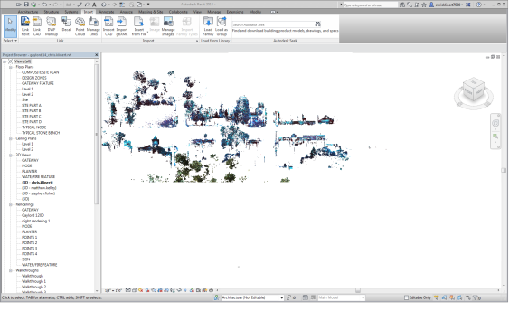
blue colors in Revit from ReCapImporting and cleaning point cloud data usally works well in Autodesk ReCap, but if your point cloud ends up turning blue after importing to Revit this Solu-around will help.

1. Import to Autodesk ReCap
2. Remove/clean up data
3. Exports as rcs
4. Open ReCap, new project select rcs file you exported and import it again.
5. The colors should looks good, export it as rcs and open it in Revit

Cyclone 8.03 update and firmware release

Cyclone update 8.03 has been released to solve a couple of issues. Most noticable it provides the ability to import P20 data without requiring a network or wi-fi connection.
8.02 upgrade to .03

Leica ScanStation P20 Firmware V1.21 05/29/2013 is available for the P20. Be sure to to install this on the P20 or blue coloring can appear during outside photos.
P20 bad image

Photos to Point Cloud Autodesk ReCap Photo

P20 from photos
7 steps to create point cloud from Photos. For the first project just take photos around the entire object, have fun and review results.

1. Take pictures around an object.
I used this video to learn and complete my first project. http://www.youtube.com/watch?v=vPIZlcwZQJM
2. Log into https://360.autodesk.com
3. Upload images of an object that you took.
4. Select my cloud documents in the upper right corner.
step 1

5. Select all of the photos that will be used; right click; select create 3D model
step 2

6. Will receive an email once the point cloud is completed.
step 3

7. Open rcp file in Autodesk ReCap.
P20 from photos

ADSK Solutions,LLC offers training, support for Autodesk, point cloud deliverables and 3D laser scanning rentals and sales.

Support
I received an error on my first try. (Browser not supported) I closed internet explorer and opened google chrome to resolve this issue.

When creating the model draft mode will provide the quickest results but will not provide the files to review the model. Select anything but draft mode to review the rcs file in ReCap.

SPAR and Pointclouds in InfraWorks 2014

Video

ADSK Solutions had the pleasure of presenting 2014 pointcloud workflows in the Autodest booth at SPAR. This is a small look at whats to come. ADSK Solutions offers mobile scanning rentals and purchases. Automatic linework extraction software and the latest 3D scanning techKNOWLEDGEy available. Download 2014 Autodesk ReCap today to get started. Contact ADSK Solutions to become experts and well known in this industry. Info@ADSKsolutions.com